Google Maps is widely used for navigation and is considered one of the best applications for this purpose. As you zoom in on Google Maps, in satellite view you’ll notice each building, place, vegetation, roads, and lakes, but especially in Indian Maps everything appears somewhat blurry and lacks clarity. On the other hand, if you look at satellite imagery of developed countries, such as the USA, Europe, or the UAE, it appears much sharper and clearer. Why is there such a disparity? Why this discrimination?
Also Read: 3D Printed House In India: Cost, Inside, Details Everything
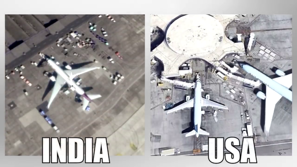
Maps of India Vs Other Developed Countries
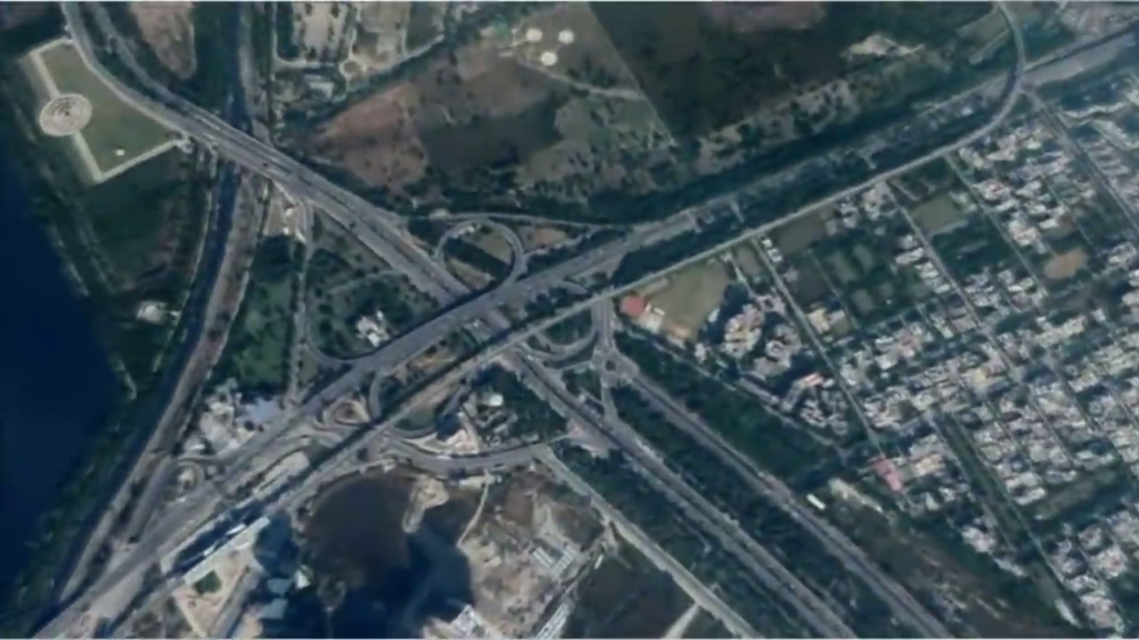
First, let’s look at a small comparison of satellite imagery details in our country. You can see satellite imagery of roads and buildings. There is a lack of sharpness, image looks a bit blurry, here is another example look at the details of the airport.

Now let’s compare these with developed countries as shown in the image below. You can see the difference.
Why does India’s satellite view on Google Maps show blurry
There are two main reasons behind the lack of detail in Indian maps.
Reason No: 1
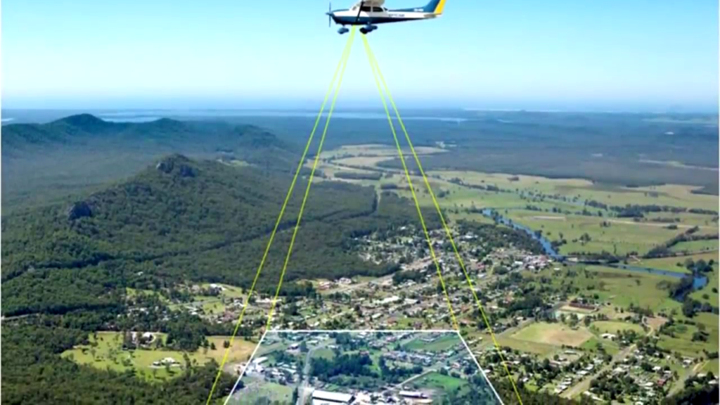
First, it’s important to know that most of the satellite imagery you see for important cities is not captured directly by satellites. Instead, helicopters, airplanes, and drones are used for this purpose. Google or Google’s data providers install various equipment on planes or drones and fly over different places to capture detailed images.
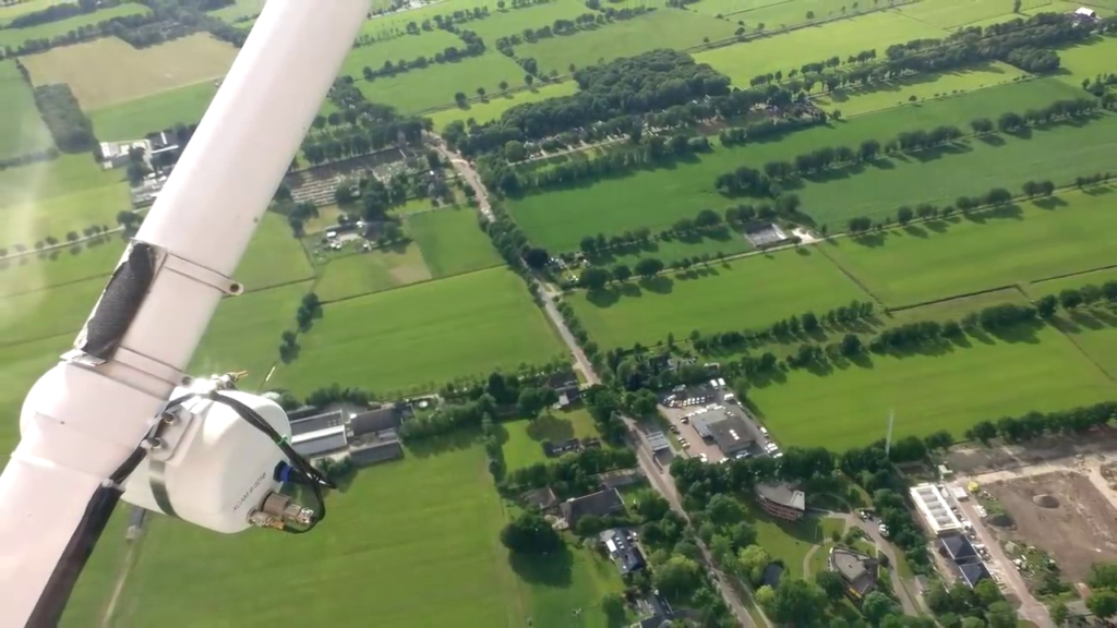
In India, private companies do not have permission to conduct aerial imaging using helicopters, planes, or drones. Even if permission is granted, strict regulations apply. This is why Google and its data providers do not use planes for imaging in India. Therefore, India relies entirely on satellite maps. In some of the developed countries where permissions are granted, images captured by planes and drones are synchronized with satellite imagery using artificial intelligence, resulting in clearer images as you zoom in on the satellite view of Google Maps. The imagery captured by planes and drones is referred to as aerial photography.
Reason No 2:
The second and most important reason is the law of our country. In India, private companies have a limited resolution for general use, which is a maximum 1-meter spatial resolution or 1-meter ground sample distance (GSD).
This means that the smallest pixel in the satellite photo corresponds to an actual ground area of 1 meter by 1 meter, and this is the maximum permissible resolution. In some places, even lower resolutions are permitted.
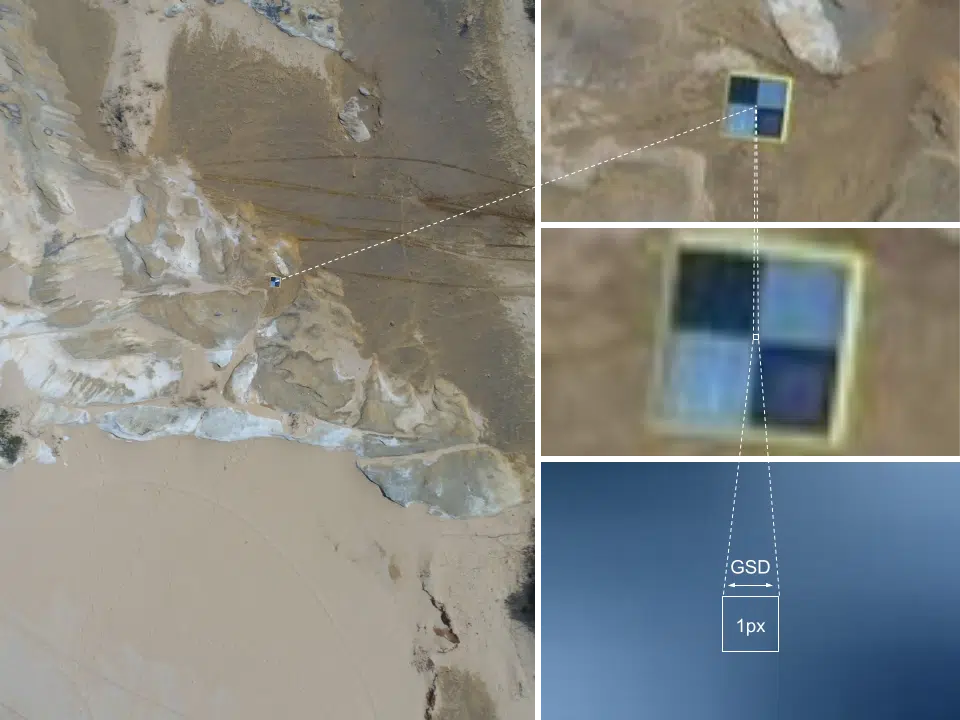
Resolution refers to the level of detail in an image. As resolution gets higher the smaller the squares will be, which means more detail we have in an image.
Understanding the Resolution
When you watch a video on YouTube, you are presented with options such as 480p, 720p, and 1080p. What does this mean? It means that the full resolution will be as follows: 480p corresponds to 854×480 pixels (854 squares vertically and 480 squares horizontally), 720p corresponds to 1280×720 pixels (1280 squares vertically and 720 squares horizontally), and 1080p corresponds to 1920×1080 pixels (1920 squares vertically and 1080 squares horizontally).
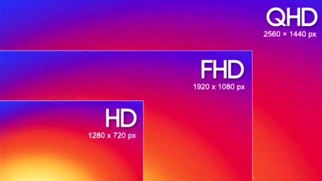
In normal photos, the squares are very small, so small that you can’t even see them with your naked eye. However, in satellite imagery, due to the large scale, these squares can range from a few centimeters to several meters.
Is Google Maps Used By Bad People?
When Google Maps was launched in 2005, Google decided to display maps of all countries on Google Maps. However, at that time, the technology was new, so many countries felt that displaying their country’s map and sensitive geographic information on another country’s platform was not appropriate.
Therefore, many countries refused to show their country’s map on Google Maps. Mainly Russia, Australia, and India refused to display their country’s map on Google Maps.
But with changing times, all countries started using Google Maps, and people started benefiting from it. People could go anywhere using Google Maps. Keeping this in mind, all developed countries are eventually permitted to show their country’s information on Google Maps.

However, India had some additional concerns. India is surrounded by enemy countries, so India did not want to share sensitive information such as border military bases and road networks with another country’s company. That’s why India refused to display its map in high resolution on Google Maps.
Don’t Miss: What is Wormhole? Is Wormhole Real? Secret Story
Indian defense agencies were afraid of exposing India’s vulnerabilities by making map information public. So security officials told Google to display India completely black on the map. But Google didn’t agree; they said that showing such a large country completely black on the map would be strange. That’s why Google blurred the map of India.
Why 1 Meter GSD Limit?
When the trend of satellite maps started a few years ago and satellite maps became available to the general public, the government decided that due to security reasons, permission could not be granted to the entire population and companies to use high-resolution satellite maps. This is why a standard of 1-meter Ground Sample Distance (GSD) was set. If there is a satellite that can capture more detailed imagery, it is virtually restricted, and artificial blur is applied to limit the resolution to 1 meter GSD.
Obviously, this was done so that our country’s military establishments, road networks, or sensitive areas could be protected. The concern with higher resolution was that it could be exploited for wrongful purposes, and this concern was shared by governments worldwide at first. However, as technology advanced and the use of maps diversified, industries began to demand higher resolution from governments. Therefore, governments of developed countries update their resolution every 4 to 5 years. They initially started with resolutions of 2-meter GSD or 3-meter GSD, but now they permit even finer resolutions. The last GSD update for companies in India was done in 2011.
Google Street View is Now Allowed in India
In some specific locations in India, street view is now allowed, where you can view according to your needs. Initially, street view was not permitted. If you’re unfamiliar with street view, let me give you an example: sitting in Kolkata, you can virtually walk in Delhi’s Lodhi Gardens. Such experiences can be viewed on your phone. If you have a VR headset, you can experience a 360-degree view.
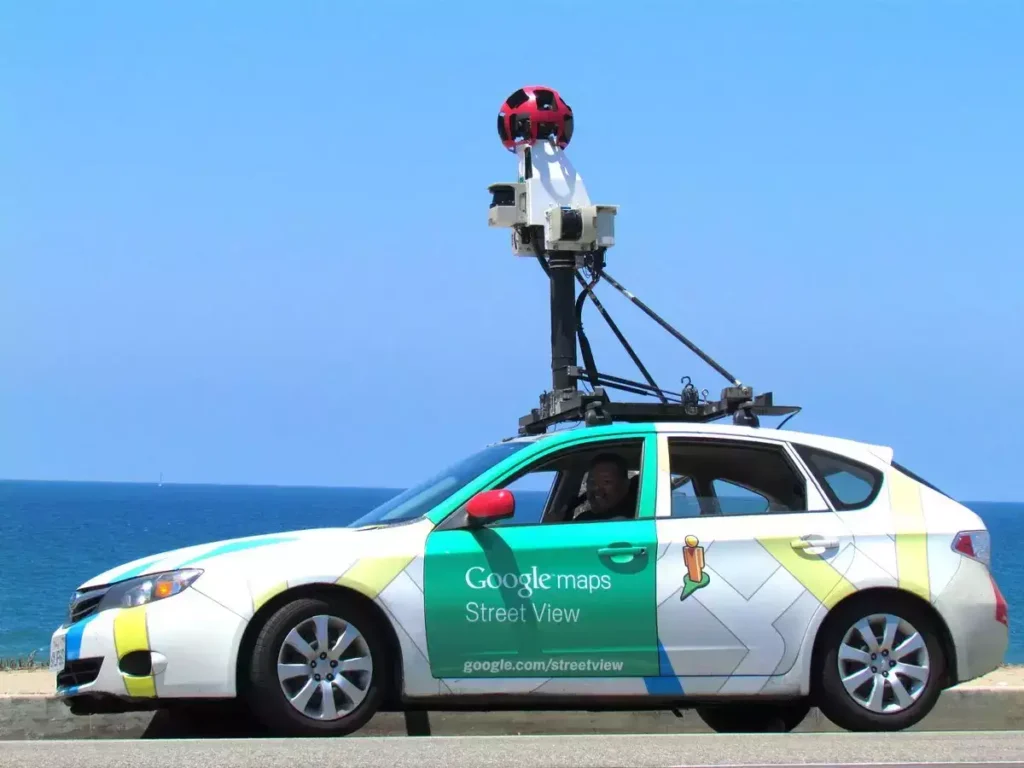
The footage you see in street view is captured using special 360-degree cameras. These cameras are mounted on different modes of transport depending on the location. Sometimes they are mounted on cars, sometimes on bicycles, and occasionally people carry them on their backpacks. Where vehicles cannot go, people carry camera-mounted backpacks.
As the camera moves, it captures slightly overlapping images to ensure a flawless view without gaps. Then, with the help of special software, the images are stitched together, and if faces or car number plates are visible, they are blurred.
In the Concluding Lines…
In conclusion, the evolution of satellite mapping technology has been accompanied by complex considerations of security, privacy, and accessibility. Initially restricted due to security concerns, advancements have led to increased demand for higher resolutions. Governments worldwide update resolutions periodically to balance security with public and commercial needs.